UPDATE
A coastal trough is expected to remain offshore so widespread severe weather is no longer expected, but localised heavy rainfall remains possible.
The low currently off the southeast Queensland coast may bring isolated heavy rainfall to the flood watch area with thunderstorm activity.
The most likely timing of the isolated heavy rainfall is from Monday afternoon through to Tuesday evening.
The heaviest falls are likely to occur around the Sunshine Coast area on Monday and extending southwards to the Queensland – New South Wales border during Tuesday.
Minor flooding is possible in the flood watch area from Monday evening.
Localised flooding and disruption to some transport routes are likely.
Noosa River and Sunshine Coast rivers and creeks are among the catchments which could be affected.
Damaging winds and dangerous surf are no longer expected, but a hazardous surf warning remains.
Most open stretch beaches on the Sunshine Coast were closed during the Easter long weekend.
Riley Mitchell, Lifesaving Services Coordinator on the Sunshine Coast, said dangerous conditions and a 2-4m of swell were present on Sunday.
“Since Thursday the swell has been increasing and there’s a lot of rips and underlying currents,” he said.
“We’ve found the public have been very good, listening to lifeguards and lifesavers.
“Wth treacherous conditions they have pretty much been staying at home.”
“The beaches aren’t as populated as we imagined they would be during the Easter break.
“That’s a shame people can’t come to the beach but they’ve definitely listened to the lifesavers and lifeguards and stayed at home, which is great to see.”
Beach numbers decreased from 32,000 on Friday to about 6600 on Monday.
Mr Mitchell expected many of the region’s beaches are expected to be closed tomorrow.
Mooloolaba and Noosa Heads have still been open for swimmers.
Hundreds of surfers have converged between Noosa main beach and Granite Bay during the past few days to make the most of the waves.
EARLIER
Heavy rainfall, damaging wind gusts and dangerous surf threaten the Sunshine Coast on Monday, as an offshore trough moves closer to the region.
A subtropical low off the Capricornia Coast, combined with a strong upper level low, is set to move south and be off the coast of Rainbow Beach or Noosa Heads later in the day.
Six-hourly totals of up to 160mm are possible between Hervey Bay and the Sunshine Coast, while isolated falls of up to 250mm are possible, particularly at Fraser Island.
Overnight, the low remained offshore and severe weather stayed largely away from the coast, but the risk of severe impacts remains on Monday, should the low move closer.
A severe weather alert issued early Monday warned of heavy rainfall that may lead to flash flooding, while damaging wind gusts of up 90km/h could affect some communities.
Local journalists supporting local people. Help keep independent and fair Sunshine Coast news coming by subscribing to our free daily news feed. All it requires is your name and email. See SUBSCRIBE at the top of this article
There should be large and dangerous waves of up to 3m on the Sunshine Coast and surf lifesavers recommend people stay out of the water.
A flood watch is in place and minor to moderate flooding is possible in catchments of the Mary River, Noosa River and Sunshine Coast rivers and creeks.
“What happens today is going to be heavily dependent on the fine movements of that trough,” Bureau of Meteorology forecaster Matt Marshall said.
“If it moves a little bit further towards the coast we’ll see the rainfall and thunderstorms building around the Sunshine Coast. If it moves a little bit further offshore all the rain will fall there and we won’t see much impact on the coast.
“So it’s sort of on a knife edge at the moment. We’re not 100 percent sure which way it’s going to move.”
Mr Marshall said there is more certainty surrounding coming days.
“It will be clearing on Tuesday (with) the trough pushing offshore, so we’ll see impacts on the coast easing. There should still be rainfall around but the main system is moving offshore.”
Queensland Fire and Emergency Services advises that people should:
* Never drive, walk or ride through flood waters. If it’s flooded, forget it.
* Keep clear of creeks and storm drains.
* For emergency assistance contact the SES on 132 500.
There were showers and some rain on the Sunshine Coast on Easter Sunday. Eumundi (30mm), Cooroy (29mm), Maleny (24mm) and Eerwah Vale (23mm) saw significant rainfall figures, and Sunshine Coast Airport recorded SE wind gusts of almost 50km/h overnight.

Only a few brave souls were taking to the ocean, Sunday, including surf lifesavers preparing for the upcoming Australian championships. Most stayed in the protected waters close to shore along the Mooloolaba Spit.
Those who ventured further out faced some challenges and a pair of outrigger paddlers came to grief.
They capsized when struck side-on by waves as they approached the safety of the Mooloolah River mouth and were sent tumbling into the bay.

A pair of outrigger paddlers cling to their craft after capsizing near the mouth of the Mooloolah River. Picture: Peter Hall.
The young paddlers became separated from their craft, but regained it, climbed back aboard and eventually snuck into the river with a story to tell.
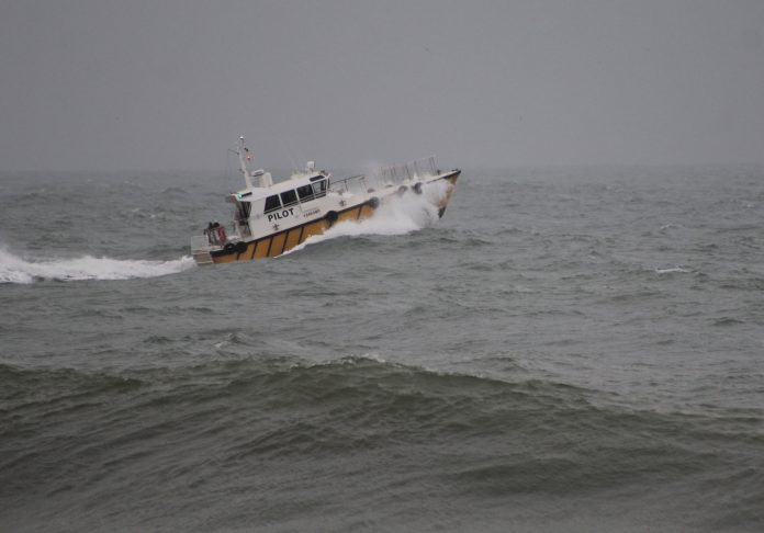
The rising seas and powerful winds were no problem for the Mooloolaba Pilot Boat, however, as it surged to sea watched by rugged-up walkers clutching their umbrellas tightly in the stiff breeze.


