

Strong swells, scorching heat and thunderstorms – that’s the wild medley bound for the Sunshine Coast.
A concoction of conditions is set to hit the region during the next week.
Bureau of Meteorology community information officer Danny Johnson said there could be some diverse conditions.
“We’ve got about three systems in play in Queensland, so we’re seeing different weather patterns happen,” he said.
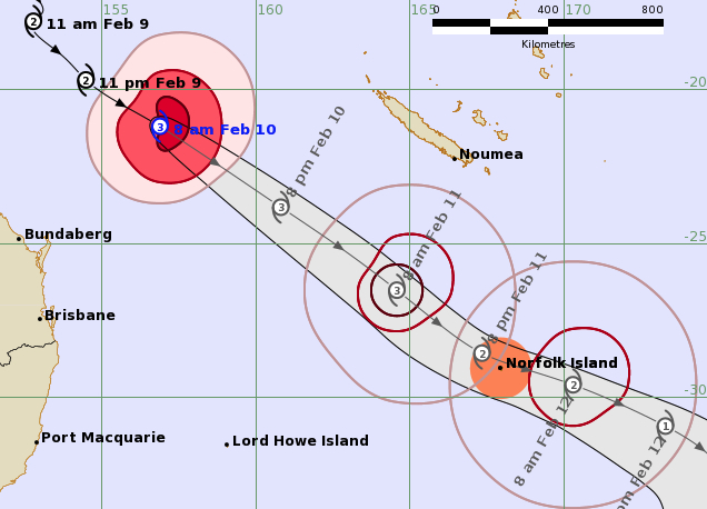
Mr Johnson said powerful surf and strong offshore winds, generated by Tropical Cyclone Gabrielle, were expected first.
“The cyclone is moving southeast in the Pacific Ocean towards Norfolk Island, and as a result we’ve got hazardous surf and marine wind warnings in place for a couple of days,” he said.
“The cyclone is heading away from the coast but we’re still seeing some of the effects, with big swells and some of the winds on the coastal waters.”
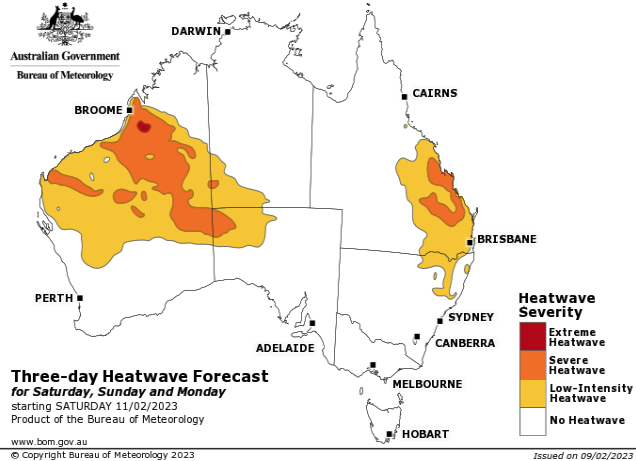
Then a heatwave is set to kick in.
“There’s a monsoon trough to the north, and the cyclone heading southeast is drawing a lot of that hot moisture air (to the south),” Mr Johnson said.
“So, we’ll have some warm northeasterly winds next week and another heatwave, like the one last week.
“The northerlies will bring a lot of warm, tropical moisture air to the southeast and it will sit here, particularly from Sunday until Tuesday.”
Temperatures are expected to reach 33 degrees on Sunday, but the apparent temperature (feels like) should be significantly higher due to the humidity, dew point and warm northerly wind.
Thunderstorms and showers are then expected.
“We’ll have a little system where we return to summer storms, with a trough coming through from the coast,” Mr Johnson said.
“We’ll most likely have storms around southeast Queensland, particularly along the coastline.”

Forecast
- Friday: 29 degrees, possible shower, large and powerful surf conditions, SE winds to 30km/h.
- Saturday: 30, sunny, large and powerful surf conditions (possible heatwave).
- Sunday: 33, sunny, N change (possible heatwave).
- Monday: 30, shower or two, E change, chance of a thunderstorm (possible heatwave).
- Tuesday: 30, shower or two, chance of a thunderstorm (possible heatwave).
- Wednesday: 30, shower or two, chance of a thunderstorm.
- Thursday: 31, possible shower.
Local journalists supporting local people. Help keep independent and fair Sunshine Coast news coming by subscribing to our free daily news feed. All it requires is your name and email. See SUBSCRIBE at the top of this article.