Unusually intense summer conditions are expected on the Sunshine Coast during the next few months, and a cyclone could encroach on the region.
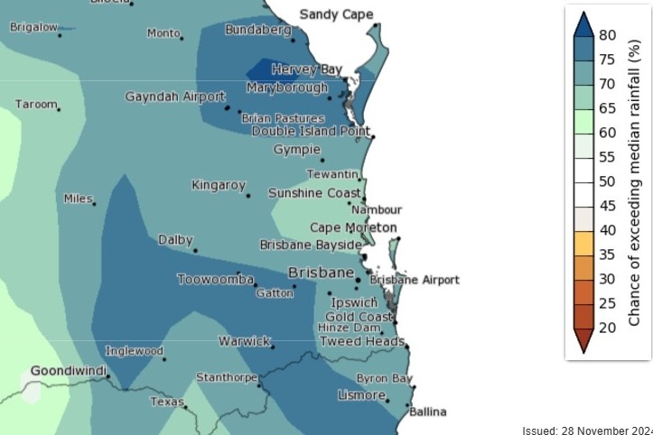
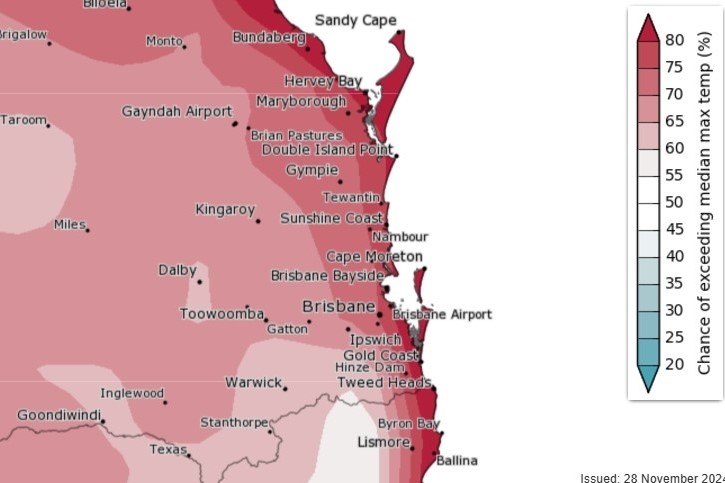
The Bureau of Meteorology has detailed its season forecast for the area, stating that there is a significantly greater chance of higher rainfall and temperatures – increasing the potential for flooding and heatwaves.
“It’s likely to very likely to be wetter and warmer than usual,” a BoM spokesperson said.
The spokesperson said rain gauges could be full, particularly during one month.
“The long-range forecast shows that we are likely to very likely to see above median rainfall for December through to February,” they said.
“The strongest signal for above median rainfall is in December.

“There is 1.5 times the normal chance of seeing unusually wet conditions for December to February, but this increases to 2.5 times the normal chance for December alone.”
So, locals should be braced for flow-on effects.
“There is an increased chance of flooding this summer and early autumn.”
Sunshine Coast Airport’s average summer rainfall is 528mm.
The BoM spokesperson said sweltering days and nights loom.
“We are very likely to see above median maximum and minimum temperatures for December to February.”
“We are 1.5 to 2 times as likely to see unusually warm maximum temperatures.
“And we are 3.5 to 4 times as likely to see unusually warm minimum temperatures when compared to a normal summer. This could result in humid and sticky nights.

“December, however, has an increased chance of seeing cooler than median maximum temperatures away from the immediate coastal fringe.”
The spokesperson said locals should be on guard.
“There is an increased chance of extreme heat and heatwaves.”
Want more free local news? Follow Sunshine Coast News on Facebook, LinkedIn and Instagram.
Sunshine Coast Airport’s average summer minimum and maximum temperatures are about 19.9 and 29 degrees Celsius.
The spokesperson also said there was a possibility a cyclone could make its presence felt.
“There is a chance that a cyclone could track close to or over the region.”
“We are currently forecasting an average cyclone season but with the chance of any cyclones forming becoming more severe due to above average sea temperatures.
“We see four tropical cyclones in the eastern region in a typical year.”
The last cyclone to have affect the Sunshine Coast was in early 2022, when ex-Tropical Cyclone Seth tracked offshore and created large surf that contributed to the Bribie Island tidal breakthrough and brought heavy rain. Ex-Tropical Cyclone Debbie included strong winds and heavy rain in 2017 while ex-Tropical Cyclone Marcia also brought heavy rain in 2015.
Surf Life Saving Queensland lifesaving manager Natalie Edwards said people should take care at beaches around the region.
“The predictions are that it will be a warmer summer this year, however, we are also likely to see more rain,” she said.
“So, beachgoers do need to take care in the surf and understand that murky water can hide debris from rain wash, and rips and currents can appear at a moment’s notice.”


