A proposal to alter a crucial shipping channel off the coast of South-East Queensland has been detailed, amid efforts to bolster trade.
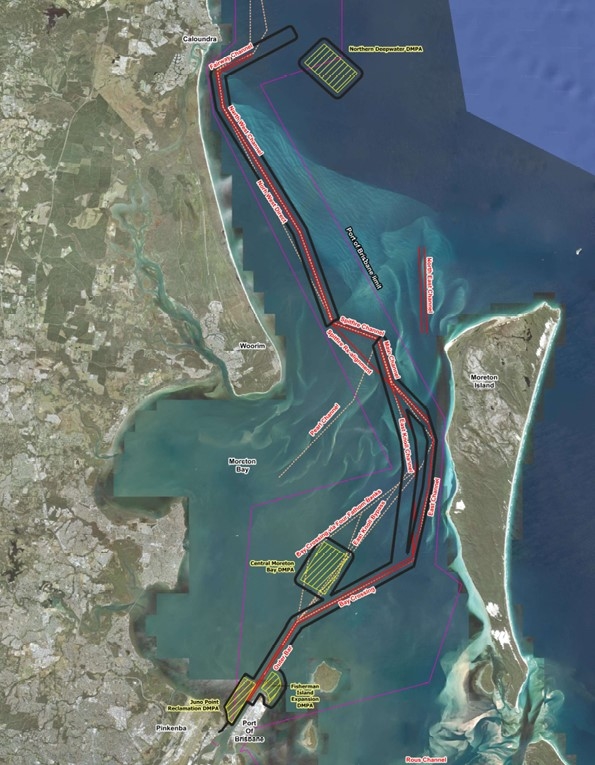
The Port of Brisbane has told Sunshine Coast News of plans to dredge sections of the 75km corridor, mainly to allow larger vessels to access Brisbane.
The proposal was also outlined in an ‘Initial Advice Statement’ for the Port of Brisbane (PoB) Channel Enhancement Project in August.
The project could include shifting dredged sediment to a placement site in deep water off the coast of Caloundra.
The PoB stated that the proposed project could take 25 years.
“It includes the potential deepening and widening of existing navigational channels, as well as minor re-alignments,” it said.
“The project aims to ensure the shipping channel servicing the port improves vessel safety and efficiency, reduces vessel emissions and caters for the future needs of the global shipping market.
“The program of work is driven by the strong likelihood that Brisbane, and the east coast of Australia, will see increasingly larger ships in the future, requiring a channel that is straighter, deeper and wider.”
The PoB said an expansion of the channel was crucial financially.
“In the global shipping industry, the vessels required to facilitate trade are getting larger,” it said.

“Currently, most container ships that visit the port are approximately 6000 to 8000 ‘twenty-foot equivalent units’ (a standard for shipping containers known as TEUs).
“Some larger vessels now visiting Australia … are unable to access the port on all tides and in all weather conditions.
“It is expected the neo-Panamax vessels of around 14,000 TEU could become the workhorse of the Australian east coast market.
“If the Port of Brisbane cannot cater for these larger vessels, it would mean additional costs in the supply chain that would ultimately be passed onto consumers. There would also be increased emissions for freight ultimately destined for Brisbane that may need to be transported over land from other ports.”
The PoB stated that it would fund the project, but estimated costs were unknown.
“A funding model will be determined once the relevant scoping and phasing work has been completed. The Port of Brisbane has committed to beginning the approvals process. No financial commitment has been made to the delivery of the project.”
The project would start after relevant approvals have been received from both the Australian and Queensland governments and a final investment decision is taken by PBPL (Port of Brisbane Pty Ltd).
“Due to the size and scale of the project, it is proposed to stage dredging over a 25-year period,” it said.
The specifics of the project are yet to be decided.
“The exact operational requirements will be determined as the planning process continues.”
“The navigational channels that form the project are between 180m and 300m wide and have a depth between 14m and 15m. The channel in Moreton Bay is about 75km in length.
Do you have an opinion to share? Submit a Letter to the Editor at Sunshine Coast News via news@sunshinecoastnews.com.au. You must include your name and suburb.
About 96.5 million cubic metres of material from the bay could be shifted. A significant proportion of that would be clean sand, but it would also include volumes of muds, silts and clays.
“All dredging works are to occur within the Port of Brisbane Port Limits and existing navigational channels,” the PoB stated.
The PoB said there were several options for relocation.
“A key part of the environmental impact statement process will be the consideration of how Port of Brisbane can responsibly place or beneficially reuse the marine sediments that need to be dredged.”

“There are potential beneficial reuse opportunities available for the sandy material that is to be dredged (i.e. potential use for building purposes, beach nourishment, land reclamation, habitat enhancement.)”
The Initial Advice Statement, compiled by engineering service BMT for the PoB, stated that dredging could start in 2028 and that one option was to move sediment to a site off the southern Sunshine Coast.
“If placement outside of the marine park is necessary, incremental placement of the dredge material at a deep-water marine placement site situated to the east of the entrance to the northern shipping channel, offshore from the Fairway Beacon at Caloundra, is preferred over other offshore locations,” the report stated.
But there could be constraints.
“The site would be situated outside of the internal waters of the state; thus a Commonwealth Sea Dumping Permit would be required,” it stated.
“The significant drawbacks of this site are that the placement of mud material would not be ‘like for like’ with the seabed, which is sand at this location, and likely short- to medium-term impacts on water quality – particularly in terms of visual plumes during placement and from ongoing wave-driven resuspension.
“Use and access to the deep-water site may also be impacted during poor or stormy weather conditions and this option represents the longest steaming time of the dredge vessel between the dredge location (at the mouth of the Brisbane River) and the northern entrance to the shipping channel (about 10 hours round trip steaming time).
“From an environment perspective, more detailed assessment of the turbidity plumes during placement and dispersiveness of the material would need to be considered as well as surveys to locate any ecological constraints such as deep reefs.”
The PoB said it was committed to the environment.
“We continue to operate with the highest regard for the sensitive marine ecosystems we operate in.
“The EIS (Environmental Impact Statement) for the project will be rigorous and thorough.
“The objective of the EIS is to identify all relevant environmental, social, heritage and economic impacts of the project and the proponent’s proposals to avoid, minimise, mitigate and/or offset those potential impacts.
“A community consultation plan will be developed as part of the EIS process and there will be opportunities for those interested to provide input and feedback.”
The PoB also provided a comment on the tidal breakthrough that occurred at Bribie Island in early 2022.
“Previous studies undertaken by the state government have concluded that natural coastal processes have resulted in impacts to northern Bribie Island.”


