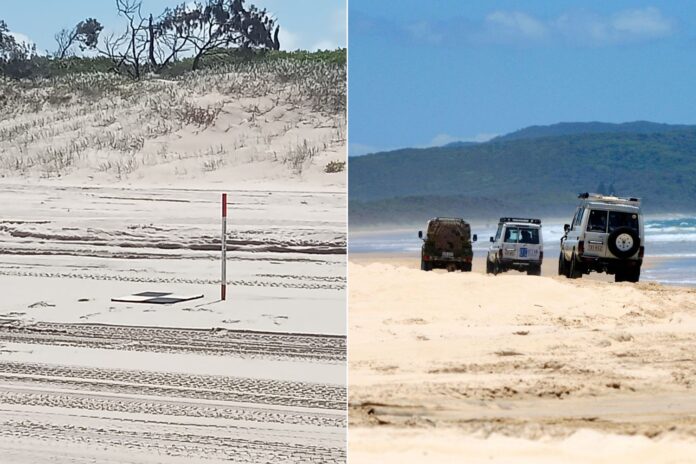
A local council has debunked speculation about works being carried out on a popular beach, after social media lit up with theories about what was happening there.
Sunshine Coast News asked Noosa Council to clarify what was happening at Teewah Beach after a post and photo on a Facebook community board last week received more than 150 comments.
“I came back from DI (Double Island) on Tuesday and saw that surveyors were on the beach pegging out a line from the beach cutting to Teewah,” the original post read.
“Apparently the council is erecting a fence to keep people from driving on the dunes at high tide and restricting travel to low tide only.”
But the council has said the markers are not for a fence but in fact for aerial surveying as part of its coastal monitoring program.
“The equipment captured in the photo on social media is one of the ground control markers which are used for aerial surveying of coastal areas,” the council’s climate adaptation strategy project coordinator Shayan Barmand said.
“It is one of many monitoring methods we use to help build long-term resilience for our beautiful beaches and foreshores.”
Do you have an opinion to share? Submit a Letter to the Editor at Sunshine Coast News via news@sunshinecoastnews.com.au. You must include your name and suburb.
Some commenters on social media were also quick to point out the marker’s true purpose.
“That is a marker post for drone flight survey control. They’ll be using the drone to undertake some sort of topographical survey – maybe a monitoring survey for ongoing dune health. Doubt there’ll be any sort of fence construction,” one said.

But others who believed the fence speculation were lamenting how the area has been adversely affected by visitors over the years.
“The only shame in this is people don’t do the right thing in the first place so these measures have to be adopted,” one comment said.
“Good in theory to stop the flogs ruining the dunes but just the start of many restrictions and regulations to come I fear,” another wrote.
Related story: Plans to save ‘over-loved’ beach hotspot revealed
The council is currently carrying out its biannual coastal monitoring program, which includes the use of drones for surveying.
This is part of the council’s long-term Coastal Monitoring Plan, which is conducted in partnership with Sunshine Coast Council from Pumicestone Passage to Teewah Beach.
The monitoring program was developed in 2022, as part of Noosa Council’s strategy to manage climate change impacts along our coastline.
“This program includes a range of monitoring activities which aim to better inform coastal management measures, identify key areas requiring future management and provide data for future coastal hazard studies,” Mr Barmand said.
The council’s surveyors completed the on-ground and aerial surveying at Teewah last week.
Further details on the program are available here.


