
A tropical cyclone off the Queensland coast could make an impression on the Sunshine Coast.
TC Alfred, which intensified to Category 4 on Thursday afternoon before being downgraded to Category 3, has steadily coursed south during the past few days, prompting residents in Capricornia, Wide Bay and Burnett regions to be watchful.
The Great Keppel Island Hideaway resort, off Rockhampton, was due to be evacuated due to predicted strong winds.
A Bureau of Meteorology spokesperson told Sunshine Coast News the system was likely to steer clear of the Sunshine Coast during the next few days but its influence could still be noticed.
Meanwhile, the BOM’s information bulletin stated there was uncertainty about how close Alfred could come to the southern Queensland coastline next week.
“Our current tropical cyclone track map shows Alfred remaining well offshore of the Queensland coast as it continues to drift southwards over the Coral Sea,” the spokesperson said.
“This weekend, it is expected to turn and move in a south-easterly direction and away from the Sunshine Coast.
“However, increased wind and wave activity is still likely along the Sunshine Coast, even if the system remains offshore.”
The BOM issued a hazardous surf warning for Sunshine Coast waters for Saturday, on Thursday evening.
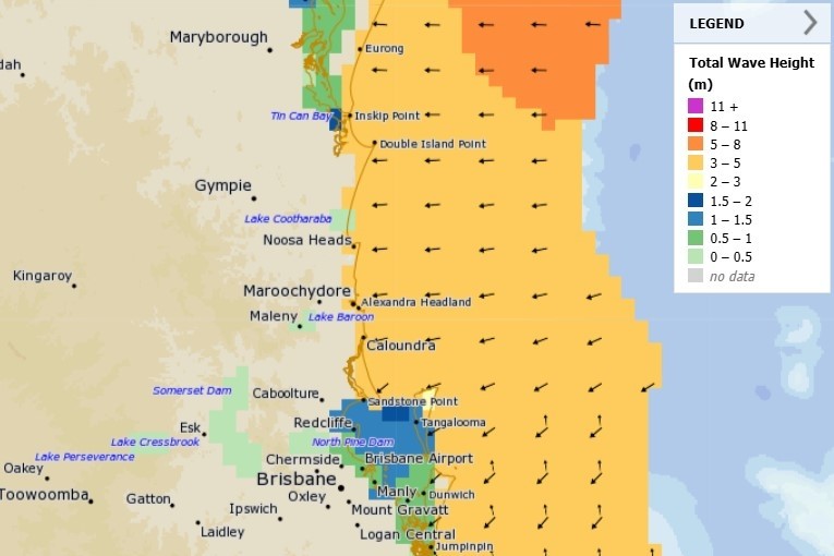
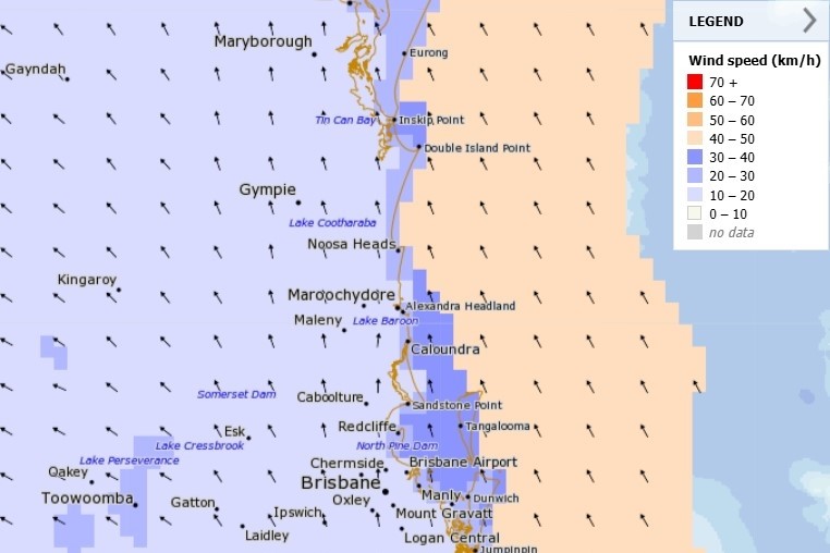
BOM forecast charts showed easterly winds could reach 30-40kmh on the Sunshine Coast over several days, while waves could reach 3-5m next week.
An information bulletin from the BOM stated there could be increased coastal hazards.
“A large and powerful to potentially damaging easterly swell as well as abnormally high tides are forecast to develop about southern Queensland beaches from Friday or during Saturday.”
Strong winds and powerful surf could also intensify tides. A 1.71m high tide was due on Friday.
The BOM spokesperson said there was uncertainty surrounding the system’s future.
“There is still a range of possibilities regarding Alfred’s movement beyond this weekend,” they said.
“Queenslanders are encouraged to keep across our latest track maps and warnings.”
The Thursday afternoon information bulletin stated there was a chance the cyclone could still move towards the state’s south-east.
“There is increasing confidence that Alfred will stay offshore of the Queensland coast, however, there remains uncertainty as to how close to the southern Queensland coast Alfred may come during next week.
“Regardless of Alfred’s path, increased coastal hazards for the southern coast are expected.”
Meanwhile, Surf Life Saving Queensland services manager Natalie Edwards urged Queenslanders to heed the coastal safety warnings and lifesavers’ guidance.
“The swell is likely to cause large waves which may combine with high tides to cause some significant coastal erosion and minor flooding about the foreshore from Wide Bay to the south over the weekend and into early next week,” she said.
A number of north Queensland beaches are closed.
