
Tropical Cyclone Alfred could make landfall in South-East Queensland later this week, and the Sunshine Coast is in the firing line.
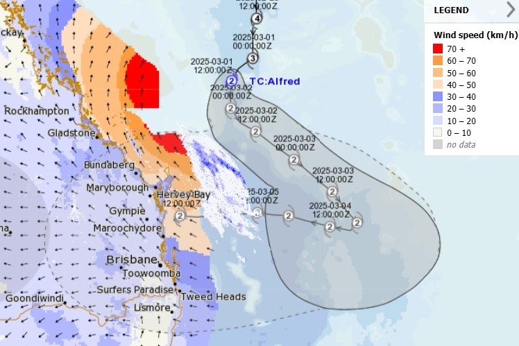
A forecast map published by the Bureau of Meteorology late Saturday indicated there was a 55 per cent chance the system could hit the greater region on Thursday.
It was issued as Sunshine Coast Council moved its local disaster management group to ‘Alert’ status to ensure operational readiness to respond to a severe event.
The BOM’s seven-day projection showed the cyclone, which was well off the coast of Rockhampton on Saturday, moving south-east during the next few days before shifting west on Wednesday and making a beeline for land, as a ridge builds to the south.
Another BOM forecast map showed the cyclone potentially crossing as a Category 2 between Gladstone and Lismore, with the Sunshine Coast in the centre.
The BOM detailed Alfred’s possible movements and impact.
“Alfred is expected to slow down and is likely to turn westward, moving toward the southern Queensland coast from mid-next week,” it stated.
“Although high probabilities of a tropical cyclone are indicated until Friday, Alfred should weaken quickly below tropical cyclone strength if it moves over land.
“Mainland and island communities along the southern Queensland and north-east NSW coast should continue to monitor forecast updates.”
Want more free local news? Follow Sunshine Coast News on Facebook, LinkedIn and Instagram, and sign up for our FREE daily news email.
There is currently a coastal hazard warning for abnormally high tides and damaging surf on the Sunshine Coast, where there appears to be a risk of Bribie Island splitting in a second location.
There is also a hazardous surf warning and a strong marine wind warning.
The local council on Saturday moved its local disaster management group status.
“The decision to move to ‘Alert’ enhances the council’s situational awareness and allows for greater collaboration with local and state government partners to ensure operational readiness, should the group be required to respond to a severe weather event over the coming days and week, on behalf of the community,” a statement said.
“Please be aware of dangerous surf and water conditions.
“Strong winds and large waves are expected to affect the Sunshine Coast region in the coming week, creating hazardous conditions.
“We urge everyone to stay safe and avoid entering the water if conditions are dangerous. We also encourage the community to continue preparing for severe weather.”
The council encouraged locals to stay informed, create an emergency plan and prepare their homes.
“We will continue to closely monitor the situation over the coming days whilst working with all relevant stakeholders to provide timely updates as necessary,” it said.
“With Tropical Cyclone Alfred potentially heading towards the southern Queensland coast, it’s crucial to stay informed and prepared.
“Now is the time for our community to look out for one another, especially our senior family, friends and neighbours.”
Surf Life Saving Queensland, the Queensland Police Service and Queensland Parks and Wildlife have also urged vigilance.
Significant rain could fall on the Sunshine Coast.
The BOM forecasts 1-20mm on Wednesday, 7-60mm on Thursday, 4-50mm on Friday and 0-25mm on Saturday.
Potential impacts
- Very strong winds could knock down trees, powerlines and blow away unsecured items.
- Power, phones, internet and water may stop working.
- Heavy rain and storm surge may cause flooding.
- Roads may be blocked by fallen trees, powerlines or flood water.
Preparation tips
- Prepare your emergency kit with essentials like a battery-powered radio, torch, tinned food, bottled water, mobile phone charger, important medicine and important papers.
- Make sure friends, family and neighbours know about the cyclone and help them if you can.
- If you have special or medical needs, ensure you have enough medicine and plan for power outages.
- Boat or jet-ski owners: Remove your boat, jet-ski, canoes or kayaks from the water and store securely on land if possible. If your boat is kept on the water, check your moorings and get ready to relocate it to a safe mooring. If your boat is in a marina, check-in with the marina manager. Check your area’s Extreme Weather Contingency Plan on the Maritime Safety Queensland website.
More information
- For all warnings, stay informed with disaster.sunshinecoast.qld.gov.au, Sunshine Coast Council’s Disaster Hub for up-to-date information and links to key emergency services in one location, including: weather warnings, road closures, evacuation centres, airport updates, traffic cameras and flood mapping.
- For weather information, visit the Bureau of Meteorology website
- For power outage information, visit the Energex website
- For traffic and road closure information, call 13 19 40 or visit qldtraffic.qld.gov.au
- If you require urgent sandbag delivery assistance, please contact SES at 132 500 or log a request via the SES app.
See disaster.sunshinecoast.qld.gov.au and getready.qld.gov.au/get-prepared for more.
