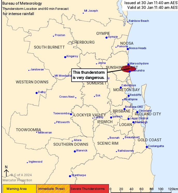
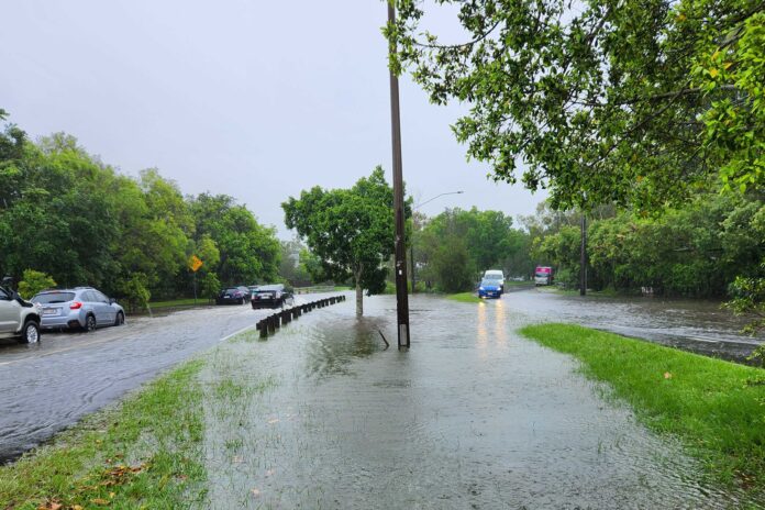
Heavy rain has lashed the Sunshine Coast, including an intense storm cell that swept through Caloundra.
Falls exceeding 200mm saturated parts of the region and caused some flash flooding, within hours.
The Bureau of Meteorology issued a warning for the cell at 11.40am, informing that a very dangerous thunderstorm had been detected and it was likely to produce intense rainfall that may lead to dangerous and life-threatening flash flooding.
That warning was cancelled a couple of hours later, after the city copped a drenching, but a more general severe weather warning remained for the region, along with flood watches for catchments including the Noosa River and Sunshine Coast rivers and creeks.
Bureau of Meteorology community information officer Patch Clapp said the storm cell quickly moved into the area and made its presence felt.
“It was pretty rapid, so we’ve seen flash flooding from the rainfall rates and totals,” he said.
“Around Caloundra, we’ve seen falls of 200mm within a few hours.
“The highest was at Bells Creek South, with 260mm, while Sugar Bag Road had 192mm.”
Water was over the road near Caloundra Cricket Club, where the fields have turned into lakes.
Club president Alex Cottrell said the grounds had received about 165mm in 90 minutes.
“Arthur Street has got water over the road. It’s coming down a fair bit,” he said.
“We’ve got cricket finals scheduled on the weekend, so that’s not ideal.”
There is a flash flooding alert for Old Maroochydore Road at Forest Glen and recurring congestion on the Sunshine Motorway at Sippy Downs and Mountain Creek, and on Caloundra Road at Meridan Plains.
According to Sunshine Coast Council’s Roads Hub site, at 12.36pm on Tuesday, 24 local roads were closed due to flooding, while about 1000 homes were without power.
Cade Mooney from Cade and Co Property took the video near the top of this story, on the corner of Nicklin Way and Beerburrum Street at Battery Hill.
“There was basically a river coming down Beerburrum Street into the Battery Hill/Dicky Beach end,” he said.
Nathan Cronk, meanwhile, also captured video of flooding, this time at Bronwyn Street, Caloundra.
Mr Clapp said the storm cell was heading north.
“It (the cell) dropped 120mm in two hours in some Moreton Bay gauges and worked its way up to Caloundra,” he said.
“It was very heavy rainfall and very quick rainfall as well.”
While the warning for that cell has been cancelled, a severe thunderstorm warning remained for the greater region.
“We could continue to see the effects of heavy rainfall through the rest of today and into tomorrow,” Mr Clapp said.

But the entire system is heading north.
Coolum West received 134mm in the six hours from 9am as it tracked up the coastline.
“There should be clearer conditions (for the Sunshine Coast) at the end of the week,” he said.
“There will still be some humidity, but not the crazy levels of it that have been around.”
He said it was highly unlikely that a similar cell to the one that hit Caloundra could occur again in the region.
“Don’t discount more rain and the potential for storms but we’re probably not going to see something like that (cell) with 200mm plus falls.”
Emergency services have been kept busy across the state’s south-east, with multiple calls for help.
Swiftwater rescue firefighters rescued 13 people as flood waters rose across the Moreton Bay, Somerset, Lockyer Valley and Darling Downs regions overnight.
Eight of those rescues were in the Moreton Bay region alone.
Samford Valley was one of the worst hit in the region, receiving 300mm of rain in three hours.
The SES also responded to 28 calls for help in the Moreton Bay region overnight.
Queensland Fire and Emergency Services have issued emergency alerts for Laidley, and Forest Hill, west of Brisbane.
Flood warnings are current for large parts of central Queensland as well as the south-east.
Flood watches have been issued for parts of western Queensland as well as much of central and southeast of the state plus north-east NSW.
The bureau said forecast rainfall in those areas could lead to flash or riverine flooding in the next 48 hours.
“In the worst case it could lead to inundation of homes, properties, businesses and agricultural land,” the bureau warned.
Ex-Tropical Cyclone Kirrily is also ensuring more wet weather in Queensland’s northwest, days after crossing the coast.
South of Cloncurry has been one of the worst hit out west with Seymour Gap receiving 256mm in 24 hours, while 244mm fell at Kirby.
Further south at Winton, all rural roads are cut with some properties set to be isolated for six to eight weeks due to floodwaters.
Help keep independent and fair Sunshine Coast news coming by subscribing to our FREE daily news feed. All it requires is your name and email at the bottom of this article.


