
Erosion on Bribie Island by wind and seas generated by Tropical Cyclone Alfred has unearthed Indigenous and World War II history.
A midden has been found near the Lions Park on the northern end of the island, where the ocean has pushed through in at least two places in the past month, after a major breakthrough in 2022.
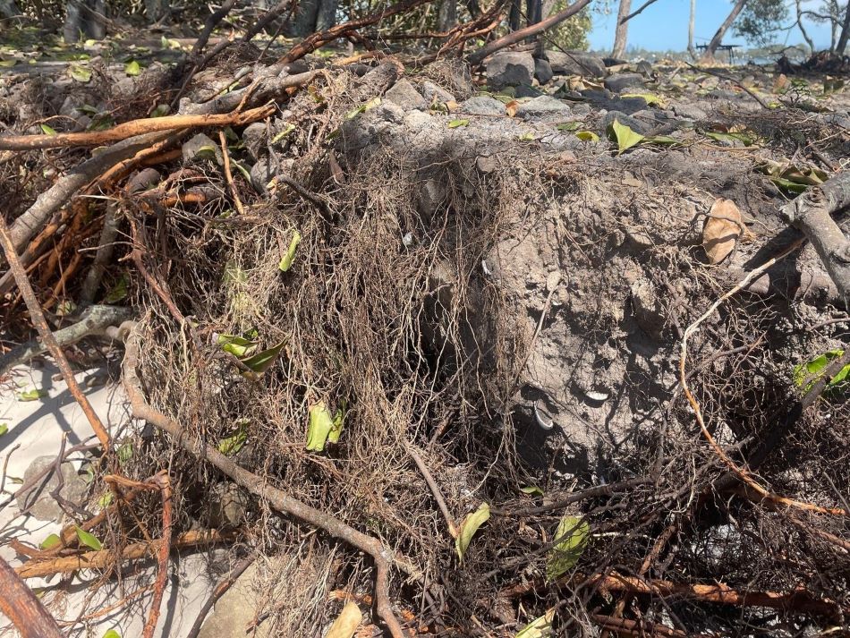
The midden was only metres away from what appeared to be a cobbled path, suspected to date back to World War II, when there was a military base on the island.
Members of the Pumicestone Passage Catchment Management Board found both on the eastern edge of the island while inspecting damage caused by TC Alfred.
The midden was spotted by PPCMB executive member and Kabi Kabi Aboriginal Peoples Corporation secretary Brian Warner, who caught sight of some shells poking out of a sand cut-out.
“I jumped down and looked underneath and there were all the shells,” he said.
PPCMB president Ken Mewburn, executive member David Clarke and treasurer Tim Hindley noted the midden was covered with rock, which they speculated had been brought to the island during its fortification in World War II.
“It looks like there’s a lot of stone on top of the midden, which is uncharacteristic for the island because it’s naturally a sand island, so stone doesn’t naturally occur on this island at all anywhere, so it’s been brought in historically at some point,” Mr Clarke said.
“If you think about this spot where we’re actually standing, it’s in specific relationship to American military fortification of the island during World War II, where the Military Jetty was established and a corresponding jetty was built on Bribie Island right at this point here.
“The ferries would have been coming across with the big trucks to deliver the concrete and everything else to make those gun installations along Bribie Island down to Fort Bribie.
“To get the trucks from the ferry across to the beach, they would have had to build a road through the sand dunes so they would not have got bogged, so these rocks have been brought in by the military during World War II to help establish Fort Bribie in this area.”
Tim Hindley, a landscape architect, said the site should be protected.
“The interesting thing is that these are sandstone rocks. They most likely have been mined locally, somewhere around Kings Beach probably,” he said.
“Normally, if it was post-World War II, they would have had the blue metal from the quarry at Beerwah or Glass House, so it’s pretty good indicator that this is a World War II-era cultural heritage item, so it should be (heritage) listed.”
Mr Mewburn said the midden was likely of significance to both the Indigenous and non-Indigenous population.
“The only rocks on this area are either those which are culturally significant to the Indigenous population of the area, or ones like this that have been brought in and would be culturally significant to the white population of the area as a wartime relic,” he said.
PPCMB spokesperson Jen Kettleton-Butler has clocked a recent recession of 10-15 metres on the island, as well as one breakthrough, and said the northern end was “hanging on by a fingernail”.
“This is just another reason why we’re doing what we say we need to do. We need to respect our cultural history, and our Indigenous and World War II history, and all of the beautiful history that Caloundra has got,” she said.
The PPCMB has been calling for action to stop the erosion of Bribie Island and maintain it as a barrier between the ocean and Golden Beach, but government departments have been reluctant to intervene, blaming the sand loss on natural processes.
The PPCMB will host a public presentation on issues at Bribie Island and proposed remedies at the Caloundra RSL on Monday, March 24, at 7pm.
